West Bay Geology
The Wider Picture
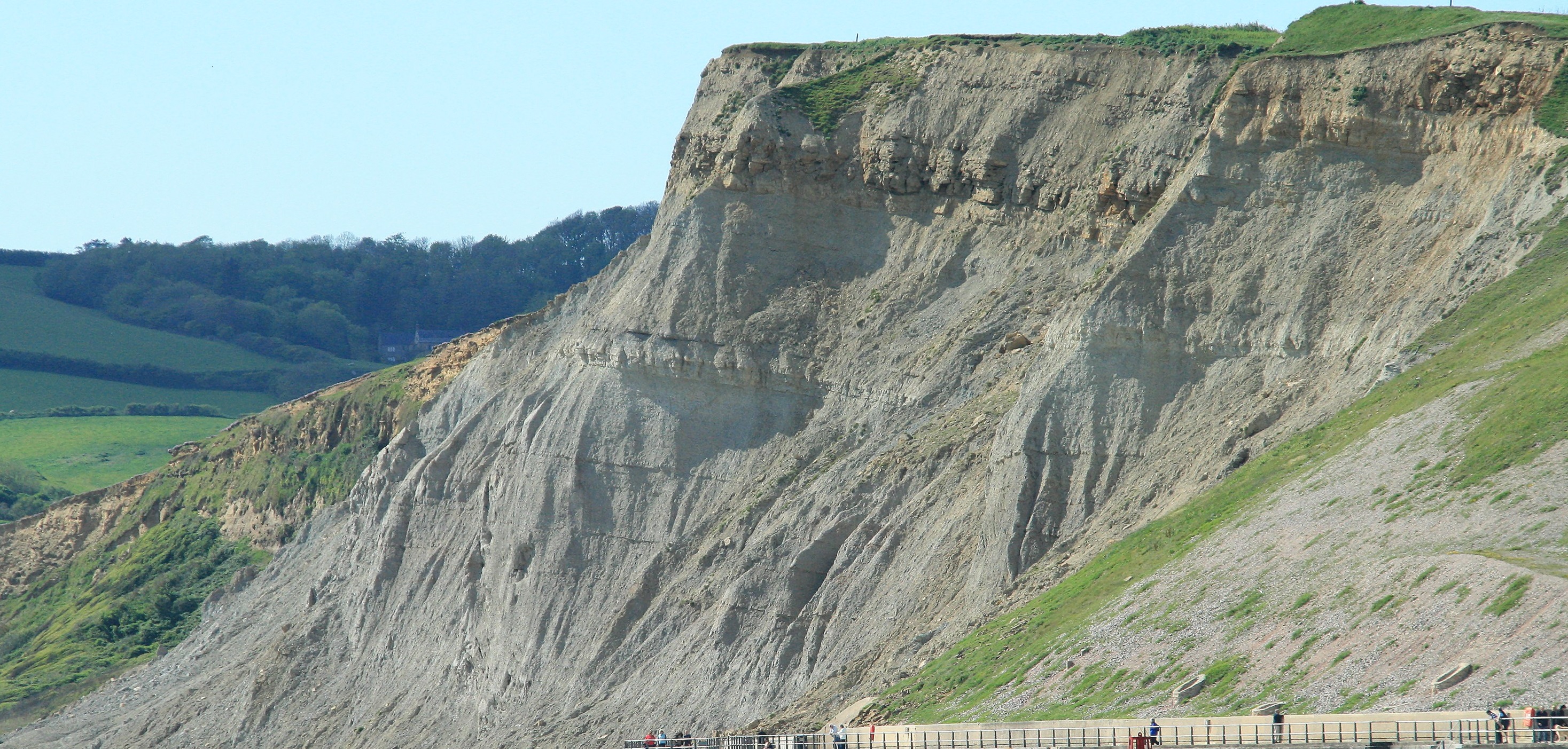
West Bay Geology
The Wider Picture |
|
Perhaps surprisingly to us now, for many people just 50 years ago the idea that large parts of the earth moved about was a tentative (at the time many called it a crackpot) suggestion. However, today the movement of the Earth's crust is a well understood and proven fact. We have measured (via GPS) North America moving away from Europe at about 2cm a year, so if anyone fancies rowing a gig to the US (I am absolutely available to cox such an adventure) you probably should not delay too long in starting.
This expansion of the North Atlantic is happening via a process of new molten lava welling up along the central part of the ocean (in the process sometimes forming mid-ocean islands such as Iceland). This rock solidifies into solid Igneous Rocks (see later section for a summary of the different rock types), in this case a rock type called Basalt and this creation of new Oceanic Crust pushes both North America and Europe away from each other. This process of Sea Floor Spreading creates new oceans. The opposite process that consumes oceans happens in places where the Oceanic Crust is pushed down (the geological term is Subducted) and subsequently melted at the boundaries of the oceans with the continents. Such subduction is not happening (yet) at the margins of the Atlantic. This is certainly lucky for us having a quiet time of things in the UK, and we don't have to worry about volcanoes or tsunamis when planning rowing outings yet. However subduction is happening along much of the margins of the Pacific, and this subduction is what is creating the volcanoes, earthquakes and mountains along much of the boundary of this ocean
So, the Oceanic Curst is constantly being created by Sea-Floor Spreading and then eventually being consumed by Subduction. Over geological timescales this type of Crust is thus transient. The oldest parts of the Oceanic Crust can be found along some of the edges of the Atlantic Ocean, and these are no more than 200 million years old, quite young in world terms.
By Contrast the Continents are much more permanent. You can think of them as permanent "islands" that get moved about by the constant creation and destruction of Oceanic Crust. Perhaps not surprisingly this also means that the crustal plates that make up the Continents are different to their Oceanic relations. Continental Crust as well as being (in part) much older, is made up of many more varied rock types, (Ocean Crust is almost all just one rock type Basalt), and Continental Crust is also much thicker, on average around five times the thickness of Oceanic Crust. If you would like to drill down into the next layer of the earth, the Mantle then the best place to do this would clearly be through "Oceanic" and not "Continental" crust. This is exactly what is being planned for the near future by a team based in Iceland, which is land that is above the sea, but which is made up of Oceanic and not Continental crust.
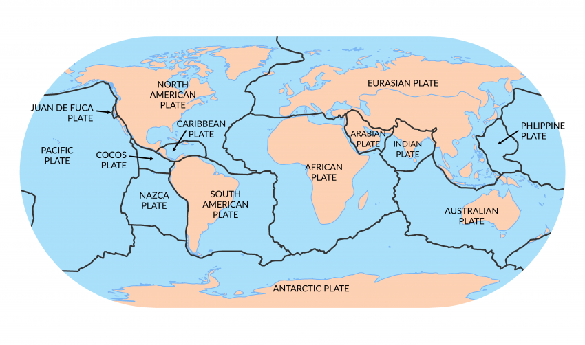
The diagram below shows the main Crustal Plates. The areas in Blue are Oceanic Plates and hence transient whilst the areas in brown as the Contienntal Plates and can be considered as permanent. The Black lines are the areas where plates "touch", note how these equate with areas known to be active in terms of Volcanos and Earthquakes.
I suspect that this is more than enough on Plate Tectonics for most (if not all) of you, but I will leave you with one interesting point. Bits of Oceanic Crust can sometimes (as part of the Subduction process get "Detached" from the rest of the ocean and get "Attached" to the margins of the Continental Crust. Effectively these become relics (you could almost say Fossils) of one type of crust stuck to the other. The reason for mentioning this is because the Serpentine rocks of the Lizard Peninsular are one example of this. So, if anyone races down that way and rows past the decidedly different looking cliffs on the Lizard you can amaze your fellow rowers by telling them that what you looking at is a "foreign body", in fact an (admittedly old and therefore quite weathered) piece of the deep ocean crust!
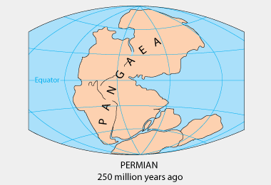
Just before the Jurassic period almost all of the solid land had coalesced via the combined effects of Sea Floor spreading and Subduction into a large single landmass, a Super-Continent called Pangaea. This happened as Sea Floor Spreading was happening more quickly than Subduction, leading to a position where all of the major continents got squished together into a single land mass. The particular piece of crust that we live on was located deep inside of this continent and was effectively "high and dry" several thousand miles away from any sea, certainly not a place for gig rowing, and probably not much of a place for living either. At this time you could (if you really wanted to) have walked from what is now the California Coast all the way to Siberia and from the top of Greenland all the way down to Antarctica, all without seeing the ocean once. The rocks that formed then in the area that was to become the British Isles were various types of desert sands, and these now form the red cliffs we can just about see down the coast around Sidmouth.
The picture below shows how the current continents were clustered together. The coastlines and borders of the current continents are shown just to help understand how things might have fitted together. Someone looking at our planet form space would have seen just a single large continent sat in the middle of a very large ocean that spread around the rest of the world. What is now the British Isles is somewhere close to the letter "A" in the Pangaea label.
The constant movement of the earth's plates however meant that just as it is inevitable that continents can move together that it is also inevitable that they will also then break up. In the case of Pangaea as the plates drifted apart it allowed the oceans to spread back to the desert areas, leading to a position where what is now the UK was a set of shallow seas, surrounded by the still remaining high mountains and land masses created when the plates originally collided. At this point in time Britain was located (in terms of latitude) somewhere similar to where the Bahamas are now. So if you imagine a place of warm seas, lapping up against still large and significant mountains this might be something close to what the our area looked like 200 million years ago. Perhaps a combination of the Caribbean (minus the rum) but with mountains such as the Alps (minus the ski resorts) close to the shore? These general conditions continued throughout the Jurassic as Pangaea slowly continued to break up and as the large mountains slowly got weathered away, with the resulting sediments falling into the warm seas to eventually form the rocks that we see today.
The video clip link below shows a lovely animation of how the breakup of Pangaea might have looked, as well as showing an idea of the subsequent movement that led to the creation of the current day continents.
Video of Pangaea breakup
The warm seas, supplied with nutrients from the weathering mountains was a perfect place for marine animals to live, and this is one of the reasons why the rocks around us are so full of fossils today. The whole science of studying fossils, called Palaeontology, was in fact kicked off in the Victorian era by people studying these (and similar) fossil rich rocks.
The conditions for life were so favourable that evolution kicked in with a will, and many types of different creatures evolved over relatively (in geological terms) short times. This explosion of new species over short time periods makes it easy to date rocks. If you see rocks in the cliffs of Whitby and they contain the same fossils as those seen under Thorncombe Beacon then you know that these rocks formed at the same time. Despite modern radio-isotope methods of dating now being available, the vast majority of scientific dating of rocks is still done today by comparison of fossils. Radio-Isotope methods are really only used to date rocks that have no fossils in them, for example volcanic rocks or granites. The classic academic work describing Jurassic fossils stretches to something like ten exceedingly large and heavy leather bound textbooks. Far more pages than for any other single geological period.
Before moving on to describe the rocks we see as we row along the coast it is probably worth mentioning that the situation described above, continents crashing together, followed by them then splitting apart has happened many times. The British Isles shows the scars of three such events over the past 500 million years. The Jurassic rocks formed upon the splitting up and wearing down of the Pangaea continent, but before this the Carboniferous rocks (the source for Coal in the UK, formed from the splitting up of a previous super-continent and before this the older rocks found in places such as Wales and the Lake District formed from an even earlier split up of a large super-continent. The "Older in the NW" and "Younger in the SE" trend that is seen in the British rocks is on a large scale a reflection of the location and direction of the line in the crust where such splitting has repeatedly happened. At some point in the far future (perhaps 100 million years into the future) the North Atlantic (which is still opening) will stop opening and will then eventually close. In the closing process mountains will be formed which will be worn away before the land splits apart again. It is very likely that this split will happen somewhere close to us along a NE to SW trending line. We will then be an area of active volcanos, numerous large earthquakes, tsunamis, etc. If anyone is still gig rowing then there would be many more things to take into account when planning a trip out!
And now on to describe the types of rocks that we row past!
Next Section - Types of Rocks
Previous Section - Geological Names
Back to Introduction