West Bay Geology
Conclusion - Bringing it all together
West Bay Geology
Conclusion - Bringing it all together |
|
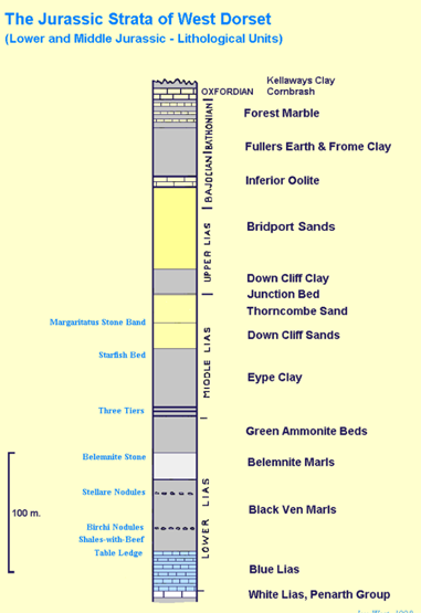
Of course, as described above there are faults and folds and tilts etc. So what we actually see are bits of this sequence in different places, sometimes repeated. The diagram below is a rough sketch that summarises what we see as row along the coast.
This shows quite well the relationships between the named rocks, and also shows the small bit of Cretaceous rocks sitting on top of Thorncombe Beacon (shown above by the yellow top layer labeled by the age "Albian"). Remember that between this and the underlying Jurassic rocks there is a gap of over 50 million years during which time the rocks were pushed up above the sea, eroded away, and then pushed back under the sea. Lots going on in this "Gap".
Cliffs are one of the few ways that the underlying geology can be easily seen. More normally rocks are hidden away under houses, roads, vegetation, soil and river valleys. To try and visualise what is going on under all of this (from a geological perspective) clutter geological maps are used. These are just plain maps which then have the "outcrop" of the various rock types printed as coloured or shaded bands over the top.
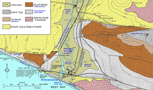
The diagram above is one such map showing the area around West Bay Harbour. Note that this is based on the original geological map drawn for our area, work that was done in the Victorian era, hence the geography shown relates to the West Bay and Bridport of over 100 years ago. If you go back to the section describing the geology of the harbour area you can see all of the features mentioned there in this map. In particular you can see the N/S trending Mangerton Fault which has shifted rocks to the right inland, and you can see the Eype Mouth Fault (which has been offset by the Mangerton Fault) causing younger rocks to be pushed down to form the land between West Bay and Bridport and the cliffs of West Cliff.
This is just a simplified summary of the small area around West Bay harbour. You can compare this to the far more simplified diagram I drew in the previous section on the area around West Bay harbour. For anyone interested in looking in more detail or over a wider area at the geological map then the British Geological Survey provides maps that can be viewed online. The link to the map for our area is listed below.This also includes a number of "cross-section" views showing how the rock beds look "sideways on".
Online Geological Map of Bridport and West Bay
I am hoping that for those who have had the persistence to get this far through my ramblings that you might even be interested to have a look further, and a good starting point is the link above. Also, if you do a google search for West Bay Geology you will find a set of web pages written by Dr. Ian West at the University of Southampton. Some of the images above have been borrowed from these pages. I can definitely recommend looking through them, as they provide lots of images and much more detail than I have provided on the geology and history of our very beautiful coastal area.
All that remains is for me to say thanks to those that have read their way through this! I know that geology for many is a tangled mess of strange terms and peculiar contradictions, so well done if you have made it this far!
I have very much enjoyed putting down in writing some of the things that I have talked about with gig crews over the years, and hope that at least a bit of my enthusiasm for the wonders of our geological heritage might have rubbed off on you. Hope to see you out on the water and thanks again for reading.