West Bay Geology
East of the Harbour
West Bay Geology
East of the Harbour |
|
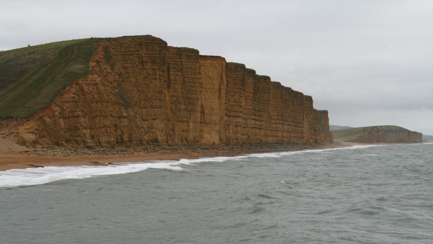
The Bridport Sands is the source rock for some of the smaller oil fields along the south coast, for example at Wych Farm. The rock is porous and can hold oil, and the horizontal layers are less porous can trap this oil and prevent it from migrating uupwards and escaping. This leads to pockets of oil that are trapped in place and which can be extracted in sufficient bulk to be economic.
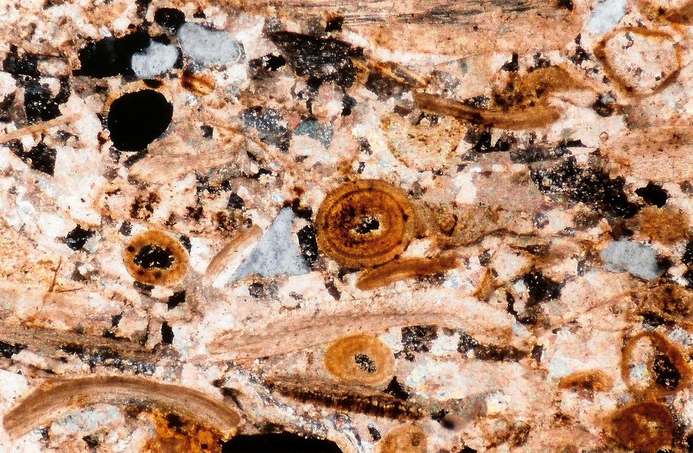
Above the Bridport Sands is the slightly greyer, but still red, rock formation called by the lovely name "Inferior Oolite". This is a shelly limestone, containing a mixture of shelly material cemented together with small grain shaped lumps of limestone called ooids, hence the "Oolitic" name. Ooids are formed in "high energy" conditions where the waves are moving around lots of broken shells, a bit like hailstones formed in clouds. The picture below is of a "thin section" (i.e. a slice cut through the rock that is so thin that light can shine through it), of an oolitic rock. The circular features are the Ooids, which are probably about 1mm in diameter (this picture was taken through a microscoope).
The "Inferior" in Inferior Oolite does not mean this is in any way a lower quality rock! It just means that this is the older or "lower in the sequence" oolite. Above this, in some localities (though not here), comes other Oolitic rocks, variously called Superior Oolite or Great Oolite. Throughout England the Inferior Oolite is often used as a building stone, sometimes in the form of blocks for building and sometimes (where the oolitic layers from laminations) in the form of slates for roofing. However I don't believe that this is the case to any large extent in Dorset as there are much better alternatives for building stone available locally.
If you fancy collecting fossils from the beach here, always look for places where there are dark brown blocks of Inferior Oolite that have fallen down, always assuming that you keep away from areas likely to experience falling rocks. In Yorkshire rocks of the same age have been known to have dinosaur remains (typically fossilised vertebrae from the spines of these creatures) and also dinosaur footprints. I don't think such remains have been found here, but if you do find some dinosaur remains I am sure that the Natural History museum would be very interested in having a look at them, as indeed would I. Anyway having now introduced any Scrable players amongst you to the word Ooids (probably for the first time) I think we should probably move on.
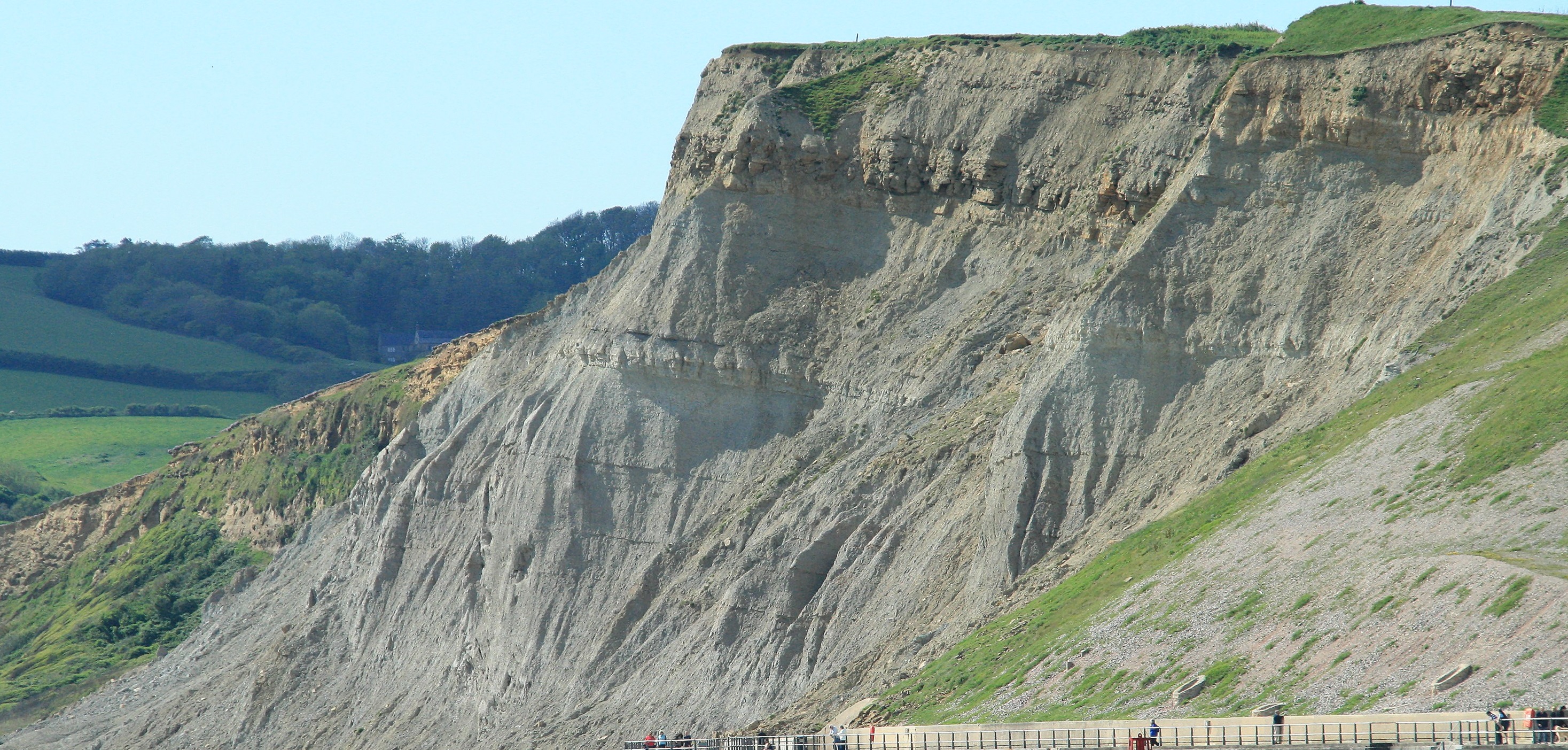
One interesting feature of the cliffs here is the dip between West Bay and Freshwater. This is a "Perched" river (or stream) valley. The rate of erosion of the cliffs moving northward is quicker than the rate of erosion of the stream (when there was a stream, it is now dry) downward into the ground, and this means that the valley that once went down to the sea is now left "high and dry" above the beach, and now in use as part of a Golf Course. The opposite situation, rivers eroding more quickly than cliffs is probably more typical, leading to wide flood plains open to the sea as you can see at places such as the mouths of the Trent and the Thames. Of course for us the quick rate of cliff erosion will mean that it won't be too long (in Geological terms) before the Broadchurch Cliffs disappear.
Another interesting feature is a red layer immediately underneath some parts of the cliff top. This is a Palaesol (ancient soil), that in this case probably was formed sometime during the last ice age, probably as a local response to a warmer period within the ice age. This is not a true rock, it would need to be buried (and heated up and squished) for it to be converted into a fully formed rock. I would guess that within this layer you might find evidence for the flora (and perhaps fauna) of the last Ice-Age, but I am not sure how to safely access the rocks to have a look! Elsewhere on the cliffs tops you can see places where the rock is fractured into tiny pieces. This is called "Head" and is the result of years of frost fracturing of exposed rock, again during the last ice age. Even though the ice sheets never got as far as the south coast, at their maximum extent, (a time period called the Devensian and which was only 20 thousand years ago, they stopped around a line running between Bristol and Salisbury, the conditions however would have remained at times very cold, sufficient to fracture solid bedrock into small pebbles over time.
The gap in the cliffs around Freshwater, like in West Bay, is caused by faulting, in this case a set of North/South trending Strike Slip faults, which have again been picked out by the river as the easiest way to get to the sea.
The exit of the river at Freshwater is "hard up" against the eastern part of the cliff. This shows the influence of the predominantly westerly source of wind and waves (at least at the present moment). Effectively the river mouth is being pushed up against the cliff by the action of the prevailing weather. I have seen old pictures of West Bay harbour, prior to much of the recent improvements and again the mouth of the river was originally (before the sea defenses moved it's course) pushed hard up against East Cliff for the same reason.
Beyond Freshwater the Bridport Sands continue. If you look at the cliffs near to Freshwater you can see evidence of yet another small fault by an offset in the boundary between the Sands and the overlying Oolite.
Rowing further down the coast we come to the Hive Beach, and guess what yet another fault. The café and car park mark the line of the fault - with sands on the west and clays to the east. The clays here are a re-appearance of the Frome Clays that are seen in West cliff, but this time slightly closer to their normal position in the sequence of Jurassic rocks, remember that progressively younger rocks tend to appear as we move from West to East. For those days with good rowing conditions and where we row on even further towards Cogden Beach you will be rowing past the full extent of Frome Clays, and looking inland you can see small hills which are the overlying Forest Marble or outliers of Cretaceous rocks sitting in a broad landscape of clays. I don't live in this area, but I imagine that many houses here have quite waterlogged gardens due to the large extent of Clay Rocks that are present.
These clays include the Frome Clay you see on the coast but also the younger still Oxford Clay. This later rock makes good bricks and there are several locations where there are remains of small quarries and brick works. If you live in an older brick built house in the area then almost certainly the bricks would have been made in one of these locations. In more modern times the supply of brick quality clay was reduced in our area and modern houses are likely to be built using bricks made closer to London, where the outcrop of Oxford (and London) Clay is much more extensive. The different ages of brick making can be easily seen by looking at the different colour of bricks by age of house.
Next Section - West of the Harbour
Previous Section - West Bay and the Harbour
Back to Introduction